Features OGOR
Optimize crop productivity with OGOR.
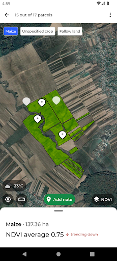
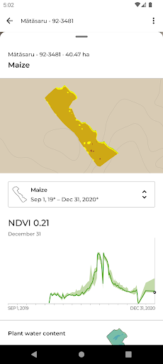
Detailed vegetation maps and weekly updated pedoclimatic data help you control every plot on the farm throughout the farming season.The app offers: • Vegetation maps updated weekly • Agronomic analysis tools • Pedo-climatic data • 7-day weather forecast • Journal with pictures and notes from the field • Collaborative access to the platform for 2 pers • Morning report every day by emailWith this suite of features, a farmer—whether working 50ha or 1000+ha—can track crop performance from a big-picture perspective, with monitoring and analytics tools to highlight opportunities to increase productivity.
Moreover, OGOR does not require new machinery, changes in agricultural practices or other high-risk investments; OGOR works with what is on the farm today.To see your farm you must first create an account in the OGOR platform, then add your parcels, either from quick retrieval from APIA (3 minutes), or by loading them from disk or even manually drawing them directly from the application.
Once the parcels are added you get a free 14-day trial period.Throughout the entire process of using OGOR, from the creation of the account to the addition of plots and the subsequent interpretation of the agronomic analysis, our team of consultants is constantly at your disposal.About the companyOGOR is a Romanian startup, founded in 2019, that focuses on satellite imagery as a reliable and inexpensive engine for agronomic inspection and analysis.
To these are added meteorological, pedological data, statistical information and state-of-the-art algorithms so that Romanian farmers can meet the climate changes and economic pressures of our times.
Weather Features
Get accurate weather forecasts and real-time updates.
Productivity Tools
Boost your productivity with powerful tools and features.
Financial Tools
Manage your finances and track your expenses easily.
See the OGOR in Action

Get the App Today
Available for Android 8.0 and above